

MapQuest
Making directions easier without the folds
During a moment when Jordan and Rodman were connecting in their first NBA finals, the film Independence Day was released, and the Spice Girls debuted their album “Spice”, a science fiction moment occurred: MapQuest launched. Maps everywhere and directions anywhere. It was the best possible solution to get you where you were going. People wanted to efficiently and accurately navigate from one location to another.
Some obstacles prevented people from getting there:
Physical limitations of paper maps: Paper maps are static, bulky, and couldn’t be updated easily, which made them inconvenient and inaccurate over time.
Complexity in route planning: Calculating the best route with a physical map required time-consuming manual effort and was error-prone.
Lack of integrated travel information: Physical maps did not offer additional personalized travel-related information such as points of interest, traffic updates, or alternative routes.

Enter MapQuest, founded in 1967 as a cartographic service producing maps. It wasn’t until 1996 that they would launch what they’re now known for: an interactive map giving you directions from A to B.
Like other products in the late 90s class, MapQuest leveraged the new internet invention. And they bundled a few more abilities to create the product. Namely, solving the complexity of plotting specific routes on a map.
Route planning can be traced back to the 60s with the development of algorithms such as Dijkstra’s. This algorithm found the shortest path between two nodes on a graph. At the time, these algorithms were mostly academic. On the edges, they were used by logistics and shipping companies to help reduce costs by planning more distance-friendly routes. Over the years, new algorithms like the Bellman-Ford and Floyd-Warshall gave the route planning community enough of a leg to stand on.
It wasn’t until MapQuest’s consumer software that these algorithms had to perform at scale. While mapping the world, a route needed to be created from any place to another, no small task. And an impossible one for a physical map. There was heavy friction in marking a map with a route each time you were going somewhere you didn’t know.
Combining scalable digital maps and providing routes was enough to make MapQuest the best product for getting directions. But they took it a step further. MapQuest was able to personalize routes with additional stops, and more information on locations of attraction that may be of interest. They perfected the combination of this new information provided by the internet and combined it with decades-old ideas to solve the simple problem of getting directions from one place to another.

A static map didn’t change, but an internet-based one could adapt based on what you wanted to see, eat, or where you wanted to sleep. MapQuest also integrated dynamic traffic information, a feature we’re familiar with today in mobile map apps. They made a paper map better by dynamically adding personalized information as they got it.

MapQuest solved the hard thing: they integrated map data digitally and cleverly scaled it to solve for directions and routes; then, they integrated personalized information, all made possible by the firehose of the internet.
MapQuest went public in 1999 and was acquired the same year by AOL. It wasn’t until 2005 when Google launched Google Maps that they would start to fade. Google Maps came to mobile in 2008, right around the time that famous phone launched. It’s not likely that MapQuest didn’t pioneer a product that billions use every day.
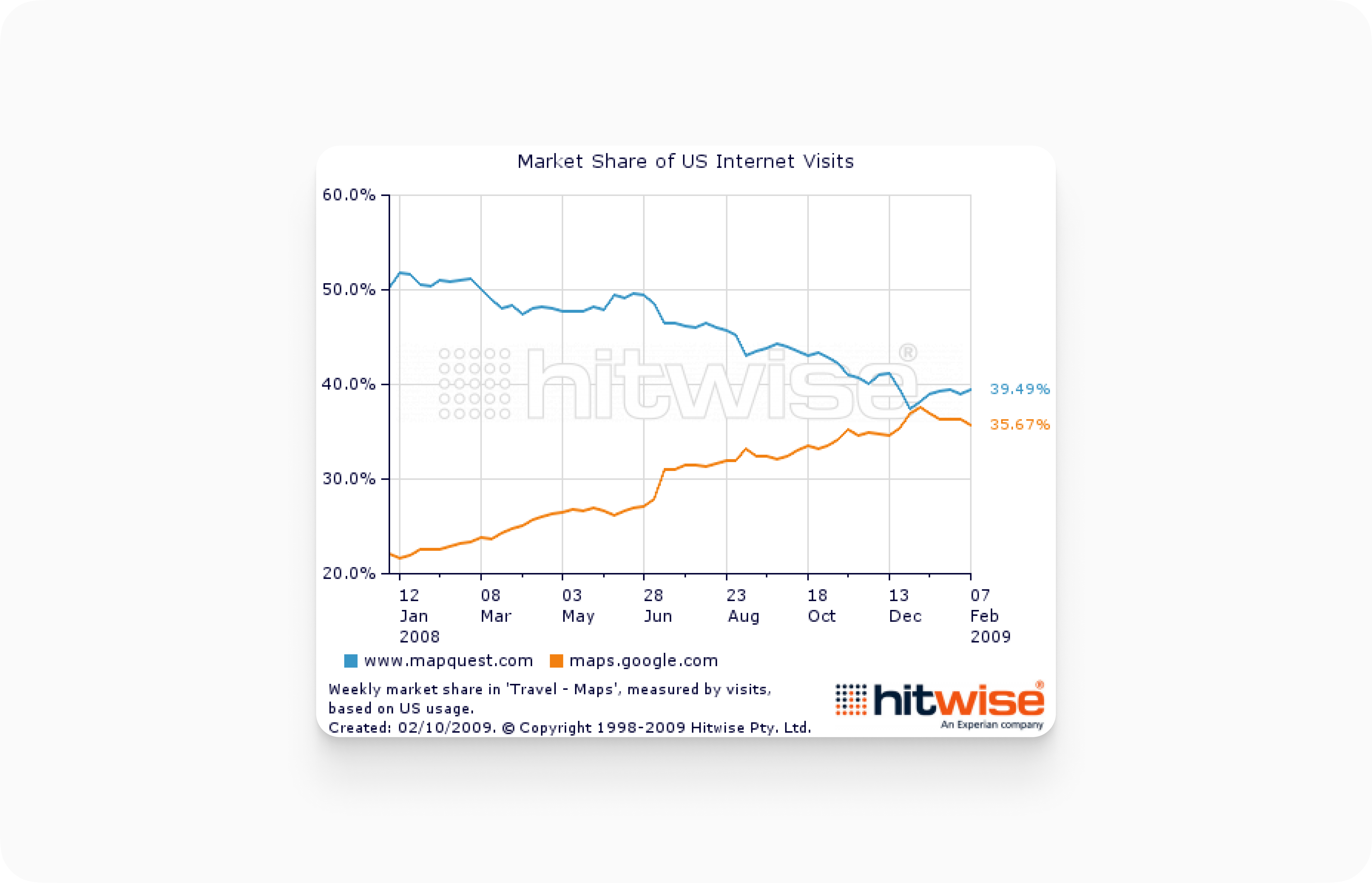
Almost perfectly, Google Maps better addressed the ongoing needs of consumers needing directions somewhere, using their phones. A new best product emerged and took over methodically. Google Maps solved a new problem set, but we’ll save that product for another time.
LOL back in 1999 I was fully dependent on MapQuest directions. They would be printed out and included in my weekly travel pack. I did a lot of flying to teach Microsoft Courses around the USA at the time.